
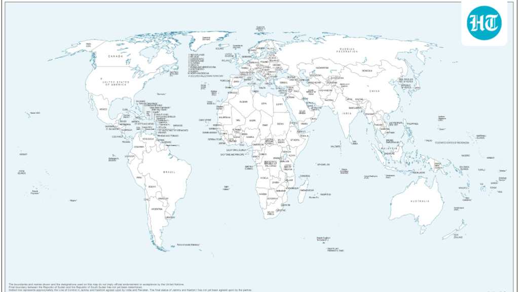
UN’s New Map Shows Arunachal, Aksai Chin Separately
Bharatmorning.com – A freshly released United Nations world map has drawn sharp scrutiny from New Delhi after the UN’s new map shows Arunachal Pradesh and Aksai Chin rendered as standalone regions wedged between India’s and China’s dashed claim lines. Rather than depicting these territories within India’s or China’s recognized borders, the cartographic update isolates each area as its own discrete zone. The Indian Ministry of External Affairs moved quickly to restate its sovereignty position while explaining why it nonetheless voted in favour of the broader General Assembly resolution that triggered the map revision.
What the Revised Map Depicts
The updated rendering surfaced on July 1, timed to active UN General Assembly deliberations on an African Union-backed resolution colloquially called “Correct the Map.” In its portrayal of northeastern India, the UN’s new map shows Arunachal Pradesh severed from Nagaland, leaving the state flanked by Assam to the west and Chinese-administered territory to the east with no shared boundary drawn. Aksai Chin, the high-altitude plateau at the centre of the India–China border dispute since the 1962 war, receives identical standalone treatment. The UN has published no explanatory note for these particular cartographic decisions.
Elsewhere on the sheet, Jammu and Kashmir is delineated with a dotted Line of Control separating Indian- and Pakistani-administered sectors. A marginal annotation reads:
“The dotted line represents approximately the Line of Control in Jammu and Kashmir agreed upon by India and Pakistan. The final status of Jammu and Kashmir has not yet been agreed upon by the parties.”
New Delhi’s Diplomatic Clarification
At a Tuesday press briefing, MEA spokesperson Randhir Jaiswal made clear that India’s affirmative vote was anchored in its backing for equal-area cartographic projection — a mathematical principle that preserves the relative visual scale of continents — and did not amount to endorsement of any single map produced by a private firm or intergovernmental body. He stressed that the resolution’s language targets projection methodology, not the depiction of any particular nation’s borders.
“The resolution is focused on the principle of having, giving weightage or giving credence to equal-area maps, so that, as we have said, the equal-area maps project or preserve the relative sizes of continental landmarks.”
Jaiswal drew an unambiguous sovereignty red line: India’s Union Territories of Jammu and Kashmir and Ladakh, as well as Arunachal Pradesh, must appear on every map in strict conformity with India’s official cartographic position. He described the government’s stance on territorial integrity as “clear, consistent and non-negotiable,” adding that any inaccurate or misleading depiction is unacceptable.
Context: The “Correct the Map” Resolution
The General Assembly approved the resolution the preceding week. Its stated aim is to encourage more equitable geographic representation of world regions — with particular emphasis on Africa, which has long been under-scaled and under-detailed on widely circulated world maps. India framed its support within that broader decolonial and geographic-accuracy agenda, explicitly distancing its vote from any judgment on individual cartographic products. The episode nonetheless underscores a recurring diplomatic tension: participating in multilateral cartographic reform while insisting that no such reform may alter the depiction of India’s asserted boundaries.
Arunachal Pradesh, administered by India since independence, is claimed in full by China as part of its South Tibet region. Aksai Chin, administered by India within Ladakh, is claimed by China as part of Xinjiang and Tibet. Both disputes remain unresolved and are periodically inflamed by border skirmishes along the Line of Actual Control.
Frequently Asked Questions
What does the UN’s new map show regarding Arunachal Pradesh and Aksai Chin?
The UN’s new map shows both territories as independent regions positioned between India’s and China’s dashed claim lines, rather than within either country’s recognized borders. No official UN explanation has been issued for this specific cartographic choice.
Why did India vote in favour of the “Correct the Map” resolution?
New Delhi supported the resolution because it promotes equal-area projection, a technical principle that preserves the relative visual scale of landmasses. India clarified that its vote was not an endorsement of any particular map or the depiction of any specific nation’s borders.
Does India accept the map’s depiction of its borders?
No. The MEA stated unequivocally that India’s sovereign territory, including Jammu and Kashmir, Ladakh, and Arunachal Pradesh, must be depicted in accordance with India’s official map, and that any inaccurate or misleading depiction is unacceptable.
When was the revised map released?
The updated map appeared on July 1, coinciding with active UN General Assembly deliberations on the “Correct the Map” resolution, which had been approved the previous week.